Continuous Global Mangrove Forest Cover for the 21st Century

CGMFC-21 is licensed by Stuart E. Hamilton under a Creative Commons Attribution 4.0 International License.
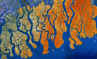
The Mangroves in the Sundarbans, Bangladesh and India.
The darker hues represent higher levels of mangrove canopy cover per-pixel.
--------------------------------------
Dataset Name: MFW, Mangrove Forest Cover Loss since 2000 in areas with year 2000 Mangrove Forest.
Period: Annually, 2000 to 2012.
Type: GIS Raster.
Format: ESRI File Geodatabase rasters (preferred), GeoTiff.
Stable URL: http://bit.ly/1lMJ9zj
Data URL: ESRI File Geodatabase http://dx.doi.org/10.13016/M2Q989, GeoTiff http://dx.doi.org/10.7910/DVN/HKGBGS, Google Earth Engine https://code.earthengine.google.com/?asset=users/stuartehamilton/CGMFC-21-2000
Citation: Hamilton, S. E., & Casey, D. (2016). Creation of a high spatio-temporal resolution global database of continuous mangrove forest cover for the 21st century (CGMFC-21). Global Ecology and Biogeography, 25(6), 729-738. doi:10.1111/geb.1244. Link.
Abstract: MFW. This raster dataset represents mangrove forest cover and mangrove forest change annually from 2000 – 2012 inclusive. The attribute value is m2 (stored as a 16 bit unsigned integer value) of mangrove cover for each pixel. The resolution is x = 0.000277778°, y = 0.000277778° or approximately 30m2 within the tropics. Attribute tables are provided. The definition of mangrove is all areas of the globe defined as year 2000 mangrove (Giri et al., 2011). The continuous data cover for subsequent years is derived from (Hansen et al. 2013). Each raster is ~618 GB when uncompressed and the entire database is ~9TB when uncompressed. The data is provided in ArcGIS file geodatabase format with both LZW lossless compression applied to the raw raster data and jpg compression applied to the pyramids. Database compression and compaction has also been applied. The actual geodatabase size is ~4.5GB. The reference system is WGS 1984, WKID: 4326 Authority: EPSG. These data are reported by country in the accompanying spreadsheet under the heading MFW.
----------------------------------
Dataset Name: TEOW, Mangrove Forest Cover Change in the Mangrove Biome.
Period: Annually, 2000 to 2012.
Type: GIS Raster.
Format: ESRI File Geodatabase rasters.
Stable URL: http://bit.ly/1lMJ9zj
Data URL: ESRI File Geodatabase http://dx.doi.org/10.13016/M2ZT44
Citation: Hamilton, S. E., & Casey, D. (2016). Creation of a high spatio-temporal resolution global database of continuous mangrove forest cover for the 21st century (CGMFC-21). Global Ecology and Biogeography, 25(6), 729-738. doi:10.1111/geb.1244. Link.
Abstract: TEOW. This raster dataset represents mangrove forest cover and mangrove forest change annually from 2000 – 2012 inclusive. The attribute value is m2 (stored as a 16 bit unsigned integer value) of mangrove cover for each pixel. The resolution is x = 0.000277778°, y = 0.000277778° or approximately 30m2 within the tropics. Attribute tables are provided. The definition of mangrove is all areas of the globe defined as in the mangrove biome by (Olson et al., 2001). The continuous data cover for subsequent years is derived from (Hansen et al. 2013). Each raster is ~618 GB when uncompressed and the entire database is ~9TB when uncompressed. The data is provided in ArcGIS file geodatabase format with both LZW lossless compression applied to the raw raster data and jpg compression applied to the pyramids. Database compression and compaction has also been applied. The actual geodatabase size is ~4.5GB. The reference system is WGS 1984, WKID: 4326 Authority: EPSG. These data are reported by country in the accompanying spreadsheet under the heading BIOME.
----------------------------------
Dataset Name: Mangrove Forest Cover Change by Country.
Period: Annually, 2000 to 2012 with projections for 2013 and 2014.
Format: Excel Spreadsheet.
Stable URL: http://bit.ly/1lMJ9zj
Data URL: http://dx.doi.org/10.7910/DVN/HS5OXF
Citation: Hamilton, S. E., & Casey, D. (2016). Creation of a high spatio-temporal resolution global database of continuous mangrove forest cover for the 21st century (CGMFC-21). Global Ecology and Biogeography, 25(6), 729-738. doi:10.1111/geb.1244. Link.
Abstract: These are mangrove levels by country for 2000 - 2012, with estimates for 2013 and 2014. This is the table most researchers require.
--------------------------------------

Mangroves in Deception Bay, Papua New Guinea
The darker reds represent higher levels of mangrove canopy cover per-pixel.
--------------------------------------
FAQ
Will the data be updated? We are planning a 2015 update (adding 2013 and 2014) available in late 2016.
Can the data show mangrove gain? Yes, if the region is in the mangrove biome (Olson et al., 2001) our TEOW 2012 layer will have all gain from 2001 - 2012. If it is not in the mangrove biome it will not show gain.
What is the correct version of the data? The GEB paper defines the different versions of the data. Without knowing your exact use I cannot tell you the best version for your analysis. Most users seem to prefer MFW.
Can you do "x" for me? Sometimes I can, sometimes I am too busy. Feel free to ask. My contact details are in the paper.