Chapter One
Pemberton Historical Park: A Monument to the Past, A Reflection of the Present
Andrew Stuhl
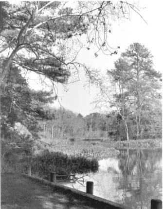
View
from wharf landing at Pemberton Historical Park.
Photo courtesy of Nicole Brown
The
speed limit on Plantation Lane is a comfortable 10 miles an hour, which both
protects the shocks on your car and allows you to take in a full view of Pemberton Historical Park.
In the driver’s seat, I watch as the park opens up before me,
inviting me to relax and stay awhile. As
I allow my SUV to manage the bumps and dips of the old dirt road, I drift
further and further from the present day and into the world of the 18th
century.
I
have come here not to simply enjoy the aesthetic beauty of Pemberton, but also
to discover what lies behind that beauty.
I have been drawn to the park by the intrigue of the rich history that
whispers through the wind-blown trees and creaking floorboards of Pemberton
Hall. I want to develop a
connection to that history. I
want to develop a relationship with the people who not only settled and
developed this land hundreds of years ago, but also those who conserved it,
preserved it, and restored this land less than fifty years ago.
I want to learn what they did here and why, how they valued the land on
which they lived, and how those values changed the land and river they called
home. I want to appreciate their
lives and what they lived for so that I can better appreciate why the land,
people, and Wicomico River are what they are today.
My
first step is to meet with Bill Wilson and tour the park.
Bill is the current president of the Pemberton Hall Foundation, which
was formed in 1963 to restore Pemberton Hall and the land surrounding it in
hopes of creating a historical education center. Bill lives and breathes the history of this area.
Not only did he co-chair the creation of the Foundation, but he’s
also put in almost 5,000 hours of volunteer service over his 28-year career
here. And when Bill says “volunteer
service,” he really means investing in incredibly detailed research,
drafting and putting in effect hand-blistering construction projects, and
fighting tooth and nail to protect his work from hungry developers.
All of this has left him with a wealth of knowledge eager to be
dispensed to anyone willing and interested.
I grab my pen and paper, do a few hand stretches, and am on my way up
the oyster shell walkway to Pemberton Hall.
Bill greets me in the front yard with a firm handshake and a smile,
wearing an unlabeled navy blue and tan cap and a gray Mary
Washington College Sweater. We
exchange pleasantries before starting on our tour.
We keep it curt; we both know that there is a lot to talk and walk
about.
A chilly breeze has picked up even though the sun shines intensely.
We begin on the southwest side of Pemberton Hall facing the Wicomico
River, the wide-bodied waterway that connects Pemberton to the mercantile
capital of the Eastern Shore, Salisbury.
If it weren't for a wall of trees erected on the banks, I would have a
clear view of the water from here. Instead,
I'll have to settle for the glimpses that escape through the cracks of the
hanging branches. Plantation
Lane cuts across my view forming a nice off-white border for a postcard-worthy
landscape. A mature oak
tree stands to my left in front of the building, casting shadows on two cozy
looking benches. Behind us, the
open and empty farmland can be seen past Pemberton Hall, stretching along the
horizon and creating a stark contrast with the rows of trees on either side. Meanwhile, unfinished worm fences slither around the house,
forming a partially enclosed play area for the front yard.
And, I must say, the yard is holding on strong for late winter.
There are some scattered patches of browning grass, but, for the most
part, it is mostly a green pattern.
Bill’s voice fades in faintly, “Let’s go down to the river.” He is already two steps ahead of me by the time my brain
processes his words.
“Sounds great,” I say. My
voice has traces of nervousness, but it is mostly filled with anticipation.
We make our way down a slight embankment beyond the road to the
secluded path that hugs the coast of Bell Creek.
Guarded by the canopy of the trees above, the trail makes for a perfect
escape from the bright sunlight. As
my eyes adjust to the dimness, the rich green color of the Holly leaves
surrounds me and the ground below becomes softer, my foot leaving prints in
the mixture of fallen leaves and twigs. Up ahead, a cleared landing awaits us. Bill strides ahead of me, obviously excited.
We reach the landing and stop to admire the view.
In the distance, beyond the marsh and swamp that dominates Bell Island,
is the Wicomico River. In all her beauty, she swims past, the sunlight reflecting
off of the water’s choppy caps. And
just at the surface, where the river meets the air, the spirit of the Wicomico
is evaporating and filling the atmosphere.
I take a deep breath, filling my lungs with that spirit, and I envision
the river in its glory: from its
beginnings as a river of seemingly endless resources, making settlement and
development possible on the very land I stand on, to its role in connecting
residents who lived here to social, political, and economic realms not only
locally, but globally, to its natural beauty that has attracted wildlife
lovers, recreationalists, and conservationists alike for over 200 years.
Through this spirit, I am reminded that this land and this Wicomico
River, bears the imprint of its human past, but it also has shaped the people
and communities based here.
Out of the corner of my eye, a long and rather old looking plank
appears. It is exposed in the low
tide as the Wicomico laps the shore.
“What’s this?” I shout, approaching the edge of the river for
closer inspection.
Bill answers, “That’s an original plank of the wharf that was built here in 1747.”
“So,
who is the architect?” I ask, figuring we should start at square one.
With a deep breath and a determined look, Bill replies, “His name is
Colonel Isaac Handy, Esquire.”
Who is Isaac Handy?
Isaac Handy
(no middle name given) was born in Somerset County, Maryland on April 13th,
1706 to Samuel and Mary Sewell Handy and was the thirteenth out of fourteen
children.
[1]
Beyond this
information, not very much of Isaac’s early childhood is known.
Scholars do know that he left his home at an early age, perhaps six or
seven, and sailed with his brother, Captain Thomas Handy, on their parent’s
sloop (ship), the Samuel and Mary.
[2]
These experiences
earned Isaac the title of Mariner before he was ten years old.
In 1721, Isaac’s father died.
[3]
Isaac was fifteen
years old. He returned to
Somerset County to find that his father had left him one half of his favorite
sloop, the other half to his brother and sailing partner.
[4]
In order to understand how Isaac would eventually treat the land, we
must first understand the values and beliefs that were instilled into him by
his father, Samuel Handy. Samuel
Handy represented the focus on economic progress that existed throughout
Somerset County in the late 17th and early 18th
centuries. Like his son Isaac,
Samuel was part of a large family and did not receive a substantial
inheritance. In order to pursue
his dreams of settling land, developing financial wealth, and building a
family, he became a redemptioner, an immigrant who lacked the funds to pay
passage to the new world and would be allowed a certain length of time to sell
their services.
[5]
Samuel
was a tobacco farmer, the main occupation of Somerset residents in the 17th
and early 18th centuries.
[6]
However, he had come
into the business at a very unfortunate time.
The tobacco market was in the middle of a thirty-year stagnation that
had begun in the 1680’s. The
only way to satisfy public demand was to develop more efficient means of
production, but these means did not come to fruition in Somerset County.
[7]
Samuel was by no means poor. Although
his business did not flourish as he had hoped, he did own vast amounts of
property at the time of his death.
[8]
This indicates that,
in addition to his wife’s inheritance, he had a prospering business at some
point in his life. In his will,
Samuel divests not only land, but also slaves, carpenter, smith’s and cooper’s
tools, and two thousand pounds of tobacco amongst his children.
[9]
The varied items in
his will not only illustrate the reliance on supplemental imports, like
carpentry and blacksmithing, which accompanied the downfall of the tobacco
business, but also the dedication to achieving economic success that was
characteristic of 18th century Somerset County.
[10]
Diversified wealth was not uncommon for a redemptioner like Samuel.
Redemptioners were not necessarily poor people, but simply children who
did not receive much inheritance. They
could easily have been sons of wealthy and educated peoples, but were not
given much with which to start out.
[11]
Redemptioners
understood that they had to forge a new path in places unknown.
This required great character and a focused drive.
Redemptioners must have been physically fit, experienced in many
different types of skills, and mentally prepared to face continual hardship.
They were pioneers, focused on establishing safe and productive living
for themselves and for their families while developing their newfound land.
The characteristics of the redemptioner can also be seen in Isaac
Handy. He was a man eager to
develop land, social status, and wealth.
Like his father, Isaac must have received much of his initial wealth
and property from his wife. Isaac
married Anne Dashiell on April 27, 1726 when he was 20 years old.
[12]
Anne was the daughter
of wealthy Thomas Dashiell of Somerset County.
[13]
Not much else is
known about Anne, which is disappointing at the least.
Isaac moved quickly and within the year purchased a 900-acre lot of
Joseph Pemberton, called Pemberton Manor, situated three miles southwest of
Salisbury overlooking the Wicomico River.
[14]
Isaac now had an
extensive piece of land, access to a river, experience with both sailing and
farming, and a growing family. It
was this land that would be Isaac’s tool to becoming a very successful man
of his time.
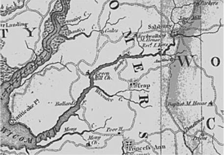
Wicomico
River, 1794. Pemberton Manor is
labeled as “Handy’s F.”
Plantation Life
Due to the widespread settlement, development, and population of the
new land, 18th century Somerset County was a time of rapid change. Beyond the tobacco market troubles, there were many other
developments occurring that had monumental effects on the settlement of the
land. For example, crafts and new
crops evolved out of the plantations as planters with larger families had more
available time on their hands.
[15]
Plantation workers
discovered that stumps could be removed during house building and land
clearing, consequently allowing for the use of the plow.
With the plow came grain crops, such as wheat, which added not only
economic benefits, but nutritional supplement.
In addition, plowing required equipment that provided work for
blacksmiths and woodworkers.
[16]
Secondly, the population was changing dramatically.
As more immigrants began to settle, the population became increasingly
“native born,” which resulted in a larger population of women and a more
even sex ratio.
[17]
Consequently, women
became the developers of the home industry.
They mastered such trades as spinning yarn, weaving cloth, butter and
cheese production, and making cider, beer, and brandy.
[18]
Furthermore, native-born populations produced larger families than
their immigrant predecessors.
[19]
This equated to more
work for the parents in order to feed and clothe a greater number of children.
As the family size grew, so did the levels of diversification on the
plantation. Parents had to depend
on the resources available to provide for their children.
Thus, they would work on extracting as much out of their plantation as
possible in as many ways possible. However,
when the children became 8 years old, they could begin to work on the
plantation.
[20]
This is also why
slaves were such an integral part of a successful plantation.
These
changes forced Isaac’s generation to view the land and use the land in new
and different ways. In this way,
Isaac Handy can be viewed as a model for his time.
His plantation serves not only as a reflection of the changes taking
place in the mid 1700’s, but also as an excellent example of the utilization
of land in the 18th century.
Isaac’s land probably did not look much like it does today. The shoreline of the Wicomico River would have been mostly
marshland, filled with species such as smartweed and wild rice, providing
nutrition for both man and animal.
[21]
The wall of trees
that I observed by the river would have had a more varied composition,
including such species as Hawthorn, Dogwood, Black Walnut, Cedar and Oak, not
to mention being altogether larger, taller, and more numerous.
[22]
A similar make-up
would have been found on Bell Island. The
forest that existed on Pemberton Manor would probably have on crept up further
on land, covering most of the property. Under
the trees, the land was extremely flat, consisting of a moist and
nutrient-rich soil. These
features of the land made profitable farming a distinct possibility.
Extensive
tree clearing would have taken place to create the room for the Handys and
their plantation. After this
clearing, the plantation became a very busy and diversified place. There was an orchard with over 200 trees of different fruit
varieties, a tannery that produced items such as shoes, a loom for making
clothes, a smoke house for hams and other meats, a kiln, and a still that
purified the fruit drinks.
[23]
The central focus of the plantation was the farm.
Isaac had developed an intricate schedule to extract the most possible
resources out of the land. Starting
in March and running until December, Isaac worked out a detailed schedule that
would include sowing flax and oats, plowing the field for Indian corn or maize
and wheat, picking cherries, harvesting the flax, wheat, and rye, cutting the
oats, planting buckwheat, planting turnips, harvesting buckwheat, and planting
cabbage.
[24]
The majority of the goods produced on the farm, as well as through the
other businesses on the plantation, would have been used to feed the growing
family. The leftovers, which were
by no means little in number, would have been used for trade.
By 1704, there were 4,437 residents in the county, which was a nice
sized market for bartering goods.
[25]
In 1725, Somerset
inhabitants had suffered such a shortage of tobacco that the Assembly
permitted payment of public debts in “country commodities,” which included
shingles, pork, beef, corn, wheat, and cider.
[26]
All of these goods
were most likely also used for bartering.
Isaac would have had a well-organized system of getting what he needed.
For example, Isaac did not have any means for producing iron.
Thus, he would have needed to acquire these goods either as import from
England, or through his neighbors. By
selling his goods, Isaac was able to account for anything that his family
needed, as well as to enhance the progress of his multiple businesses.
The
business and diversification of Isaac’s practices were a testament of his
aspirations to not only provide for himself and his family, but also to
succeed and make a difference with his life.
In Isaac’s eyes, he saw a land of opportunity waiting before him,
ready to be developed. It was
this land, the opportunities that it presented, and the changes that Isaac
exerted upon it that would dictate Isaac’s accomplishments.
Through this land and the river on which it sat, Isaac would soon
become a wealthy merchant and influential citizen.
The Rise of Isaac Handy
Summer, 1732. Life on the
plantation was good for Isaac Handy. He
and his wife spent most of their time in the good weather entertaining their
neighbors, the Winders and the Dashiells, both of which had large families.
There was major emphasis on ceremony in the Handy household, especially
with drinking tea.
[27]
The Handy’s owned a
tea table, a tea kettle, silver teaspoons, silver sugar tongs, and a silver
tea strainer.
[28]
They undoubtedly also
owned teapots and cups, and would later build a china closet to show off their
extensive collection. This
inventory is evidence that the Handy’s had enough leisure time to hold a
ceremony, had the training and manners to put it in practice, and had the
wealth necessary to purchase slaves and provide the luxury equipment.
[29]
These customs were part of a social change that was taking place in the
mid 1700’s. The same changes
that were an effect of the growing populations also applied to the lifestyles
of the Handys. Because of larger
families and more even sex ratios, parents of colonial families were able to
spend a greater amount of their time off of the plantation practicing manners
and keeping guests. Specifically
for the Handys, there were seventeen slaves, eight of which were adult hands
and two of which were old enough to work in the house.
[30]
This meant that
Isaac, Anne, and some of the older children could develop a genteel lifestyle.
[31]
This
standard of living was only possible because of the role of water,
specifically the Wicomco River, in providing a means of connection between
local families. Without the
river, the settlers would have not been able to develop the social and
economic relations that fueled the development of Somerset County.
In this sense, the river was the binding force of the 18th
century. With the isolated
populations and limited traveling capabilities, families tended to socialize
only with those who lived on or near the river.
[32]
Isaac only had a few
neighbors: John and Bridget
Winder lived at Cuttynaptico Creek, a short way down the Wicomico and James
and Ann Dasheill lived at Wetipquin Creek.
[33]
These locations were
just the right distances away so that families could still spend most of their
time together without sacrificing any business in the process. Consequently, the families had ties that continued far after
Isaac and Anne Handy. In fact,
many of Isaac’s children went on to marry members of the Dashiell and Winder
families.
[34]
Isaac’s social status began to grow through his connections with his
friends on the river, as both John Winder and James Dashiell were prominent
Somerset County citizens. In
fact, in August of 1732, Isaac was one of five people to commission a new town
in the area. As a result of the
influence of his powerful neighbors and family, Isaac easily gained this
position. Along with Isaac, John
Caldwell, (one of Somerset’s four delegates to the Provincial Assembly) John
Disharoon, (owner of the grist mill on Passerdyke Creek, now Allen) Ebeneezer
Handy, (colonel of militia and brother of Isaac Handy) and Thomas Gillis
(planter and tavern keeper at head of Quantico Creek), were commissioned by
the Provincial Assembly to divide Salisbury.
[35]
The five men were first to gather and discuss where and how a new town
would be founded. We can imagine
Isaac leading his fellow men down to the Wicomico River and engaging in a
discussion of the new settlement, while enjoying the weather and some freshly
brewed tea. Shortly following
this supposed meeting, the five men were to draft a petition that was later
presented to the Lower House of the Assembly in the July/August meeting that
suggested that there exists “a convenient place for a town at the head of
the Wicomico River.” This
petition was handled by the Somerset delegation and, following their approval,
a bill was drafted for the new town. It
was called the Provincial Assembly Act of 1732 and it authorized the
commissioners to divide fifteen acres of land into twenty lots.
They were to meet “before January 10, 1733 together on the tract of
land or some other convenient place thereto and then and there treat and agree
with the owner or owners, and the persons interested in the fifteen acres of
land for the same and after the purchase thereof.”
[36]
The commissioners wanted to build a town on the Wicomico because they
wanted to utilize its capabilities to pursue their economic ideals.
One of the most inviting features of this property was the presence of
four streams that came together and formed the river.
Those four, known today as North Branch, East Branch, Parsons Creek,
and Tony Tank Creek, and other smaller streams feeding even into them, drained
thousands of acres of land and invited the construction of dams to power
watermills.
[37]
This unique
characteristic has given support to the theory that the new town got its name
from its similarity with another town in England:
Salisbury.
[38]
After he obtained this position of power, Isaac Handy’s life changed
dramatically. He began to
develop, like many of the early settlers, “a spirit for arduous undertaking”
and a “power to sustain such an adventure.”
[39]
In essence, Isaac was
growing into the mold his father had created for him.
He had “a stout heart, as well as strong hands; able mind governed by
a will to accomplish,”
[40]
and a strong body. Shortly
after his experiences with the Provincial Assembly, Isaac developed goals and
put them into action. He began
construction on a new house to be built on his current plantation. He chose a site that would be accessible to the farm, the
orchard, and the river, and at the same time practical for easy living.
This house was to be called Pemberton Hall and would not be completely
finished until 1741.
The construction of Pemberton Hall was a marker of both the social
dominance of Isaac Handy, and his desire to develop land.
Pemberton Hall was composed of immense ten inch square beams, which
gave the house a domineering 2,500 square foot profile.
[41]
Intricately designed
and colorful Flemish Bond brickwork, the bright plaster cove corners, and the
six attractive dormer windows made up the body of the house.
[42]
There were chimneys
in each gable end, a kitchen on the east end, and a cellar entrance on the
opposite side. These lush
stylings of the house indicated the wealth of Isaac Handy, placing him in the
upper 5-6% of Somerset County.
[43]
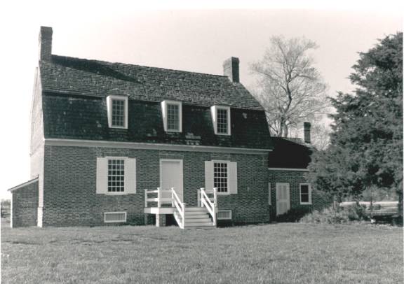
Front-view
of Pemberton Hall. Photo courtesy
of Nicole Brown.
Pemberton Hall was not only an opportunity for Isaac to exhibit his
wealth, but also another chance to further develop his land.
For each hint of personality
in Pemberton Hall, there existed a greater sense of practicality. The square beams would have come directly from the forest
surrounding the structure and the bricks would have been made on the site’s
kiln, while the iron and glass were probably imported from England.
[44]
The cellar entrance
faced the west and allows for the easiest trip to and from the river. The house was situated northwesterly in the same direction as
the passing breeze, creating a natural air-conditioner in the summer months.
And when it got too cold for comfort, the large windows acted as a
convenient heating system.
A
few years later, after the family had settled down in the new house, Isaac
decided that he wanted to expand his capacity for business.
He purchased some land adjacent to his current plantation. The most
notable feature of this land was its vast shoreline.
Isaac must have envisioned this new purchase as being a perfect site
for a wharf, as it had direct access to the river and the Bay, a flat landing,
and was close to Pemberton Hall. Immediately,
a massive clearing operation was started and a two hundred foot bulkhead wharf
was laid down in 1747.
[45]
Isaac could have
easily seen that through the Wicomico River, he could expand his business to
different parts of the county, state, and country.
Isaac’s wharf was a perfect example of how Isaac used the land
and the river in order to benefit his economic and social aims.
Unfortunately,
we do not have any records of what business took place at the wharf.
Isaac’s export lists, maritime records, or sea trunks have never been
found. Thus, we can only
speculate what may have taken place there.
Crooked Oak Lane, which lies directly across what is now Pemberton Road
from Plantation Lane, was most likely used as the rolling road to transport
barrels of goods from the farm to the wharf.
[46]
It is also a good
possibility that Isaac invited his neighbors to utilize the wharf.
Wheat flour, bread, Indian corn, bacon, cheese, butter, staves, and
cedar shingles were probably exported up and down the east coast, as far south
as the Bahamas and as far north as Boston.
[47]
It was through his
sloops, including the George, that
he was able to send his goods in receipt for other goods or money.
This is how Isaac was able to acquire the 18 leather bottom chairs from
Boston to furnish his Great Room.
[48]
Isaac, trained as a
mariner at a young age, could have made the trips himself, therefore extending
his knowledge and experience of ship sailing and industry and making
connections in such harbors as Baltimore, Chestertown, Philadelphia, and New
York.
These connections helped Isaac develop his social status in Somerset
County. He was elected in 1747 to
fill an unexpired term of Captain John Davies in the General Assembly of the
State of Maryland.
[49]
Isaac excelled at
this position and was re-elected in 1748, ’49, ’50, and ’57.
[50]
He also became a
Justice of the Peace, a position where he dispensed justice between differing
Somerset County residents.
[51]
In this sense, we can
picture Isaac as a well-known man throughout Somerset County and across the
Bay, not only to the lawmakers, but also to the law-breakers.
The wharf and the Wicomico River, which linked Isaac to a larger world,
made all of his political success possible.
These ties with the county, as well as those he made through church,
may have helped Isaac earn the title of Colonel.
Because there is little written of his military activities, it is
thought that the Presbyterian Church granted him this title.
[52]
It was common
practice for the title to be handed out in church and county records.
Also, Isaac’s now prospering wealth meant that he could provide for a
militia.
This was the peak of Isaac’s life and business career. He was a prominent figure in mercantile, political, and
religious domains and was only in his forties.
He had a large family, a loving wife, a stable career, and a network of
friends. He had been able to
develop his land to encourage his social relations and support his business
and home life. He and his fellow
settlers became not only tolerant toward each other, but they also “worked
together; submerging their differences in the will to accomplish one end-the
developing of a community in which they would have freedom of conscience in
matters of religion while gaining a substantial economic independence.”
[53]
In this way, Isaac
set a standard for 18th century Somerset County.
He inspired his peers and future developers to not only provide for
their personal and family needs, but also to reach out into the community and
encourage the economic growth that made him successful.
Changes in the Land
Winter, 1756. Isaac Handy was now fifty years old. His plantation, orchard, tannery, and wharf were all still
running, but he had taken a smaller role in their operation.
The overseeing of the plantation would have been the responsibility of
his grown sons, George, Thomas, Isaac, and William.
Isaac
spent most of his time entertaining guests and staying in the house, attending
church, and gearing up for his last year with the Provincial Assembly. He backed away from his offices in Annapolis, as Justice of
the Peace, and as Colonel of the militia and chose to spend more time at home,
with his wife and younger children. Isaac
favored the Great Room, where he could relax by the fireplace with tea, “cherry
bounce,” a product of his still, peach brandy and other fruit drinks, while
looking out at the river.
[54]
He took a liking to
smoked hams and bacon and had mastered the cooking of the fresh seafood he
caught down by the wharf. He
knew that he had developed his land along the river to foster his social,
career, and personal relationships.
Isaac
could notice a difference in his land since his purchase thirty years ago.
The soil did not seem to be as productive as it was when he first
started growing crops on it. He had learned that he could not continue to grow tobacco,
like his father did, because it exhausted the soil so quickly.
[55]
Consequently, Isaac
was forced to use a different type of practice:
crop rotation. Isaac’s
method was to crop a certain portion of his field until it could no longer
produce any crops. Then, he would
allow this area to go fallow and develop another portion of his field.
[56]
These practices
drastically damaged the land. Isaac
witnessed his plantation evolve from one with large areas of fertile soil to
one with fewer and fewer plots of available land.
He
couldn’t have known it, but the soil on Isaac’s farmland was undergoing a
major metamorphosis. From 1726 to
1756, the soil was slowly transforming from a well-drained type that could
produce a high yield of various crops into Othello silt loam, which has poorer
draining capabilities and limited production.
[57]
In addition, the
Othello silt loam that already existed around the edges of his plantation,
near the river, was slipping away into the river and forming tidal marsh.
[58]
Thus, Isaac had to
focus on land away from the river that was fit enough to perform crop
production and rotation.
These
changes were partly due to a rising water table and the subsidence of the East
Coast.
[59]
As the water
level rose, the tidal marsh gave way to tidal swamp.
This had major implications on the health of the land and the Wicomico
River. New tree species, such as
Black Gum, Holly, Swamp Oak, Red and White Cedar started to take over the
tidal marsh. This meant that the
river could no longer receive much of the vital nutrients that the tidal marsh
would collect. It also meant that
the various species of fish that would come to the marsh as a nursery for
breeding had to find a new home. Furthermore,
the wild rice and smartweed species were pushed out and were replaced with
other species, such as phragmites, arrowhead, yellow water lily, rose mallow,
and bulrush.
[60]
In addition, the forest that once covered the entire
Pemberton Manor was rapidly dwindling away.
Isaac had planned some of this deforestation himself. He had used the girdling technique to remove trees and their
stumps so that he could quickly make a densely forested piece of land
productive.
[61]
Isaac would begin
farming near the girdled trees, and after a few weeks, he would cut the trees
completely down and use them for lumber or firewood.
[62]
Isaac required thirty
to fifty cords of wood for each of his five fireplaces (Great Hall, two other
downstairs fireplaces, one upstairs fireplace and a kitchen fireplace), which
equates to 150 to 200 cords of wood per year.
[63]
A cord of wood is
four feet by four feet by eight feet. This
is an incredible number trees to be cut down each year, and the practice
occurred throughout Isaac’s lifetime on the plantation.
In these 36 years, Isaac would have used 5400 to 7200 cords of wood.
The
lack of trees on the plantation had a great effect on the land and the river
in years to come. Because trees
were not standing to protect the land from the fierce winds, the good soil on
the farm was being blown into the river, speeding up the soil transformation
and silting in the river.
[64]
This meant that the
fish that lived in the river had a more strenuous environment to live in, and
the shad, the sturgeon, and the perch, were forced to leave the Wicomico, or
died while trying to survive.
[65]
The
river then became dangerous to humans as well.
As the water became more densely concentrated with silt, it became
harmful to drink. Isaac and
others quickly learned that a refreshing sip of the Wicomico would lead to
sickness two or three days later.
[66]
Hence, water became a
leading cause of illness and possibly death during Isaac Handy’s lifetime.
Although
Isaac may have not been a decent husband to the soil as we perceive it now, he
was not exceptionally horrible for his time.
He was a man consistent with the values and behaviors of the 18th
century. It is not fair to say
that Isaac was against protection or conservation of the land, because these
ideas did not exist in Isaac’s social forum.
However, to say that Isaac was purposely hurting the land is not fair.
He was simply doing what he believed was necessary to be happy,
productive, and healthy.
Good soil husbandry may not have existed with the English settlers, but it may have existed with the Wicomico Indians that inhabited the land on either side of Pemberton Manor, at the Rotkawawkin and Tundotank reservations. [67] The Rotkawawkin reservation was built on what is now Rockawalkin Creek, adjacent to Pemberton Manor, and was abandoned shortly after 1678. [68] Isaac Handy must have realized that his land was located alongside what was formerly an Indian reservation. By seeing the remnants of the former settlement, Isaac would have decided that the land suitable for the Indians was prime land on which to live. The Tundotank reservation was located diagonally across the river from Isaac Handy’s land, along Tonytank creek, and would have subsisted at the same time as the Handy plantation. These reservations reflected the state of the land before Isaac’s settlement, which was much different than the state of the land in the mid-18th century.
The Indians settled the land with minimal impact. They lived close to the Wicomico, because the land was suitable for farming, was accessible to the river, and was close to the food source, the tidal marsh, which provided not only plant life but also animal life on which to feed. The towns they formed on the waterfront consisted of many small homes made from local materials. This where the name “Wicomico” comes from, which means “Place where houses are built.” They were widely dispersed and used trees for protection, which prevented massive clearing. They were also not permanent communities. The Indians would move between towns and campsites to accompany the changes in their diets. [69] In this sense, the Indians were able to live safely without drastically altering their environment.
Fishing, hunting, and farming comprised the bulk of the Indian’s impact on the land. However, the Indians were able to use all of the resources of the land equally without depletion. In the spring, Indians relied heavily on the land and water animals for nutrition, as their plants were not yet ready to harvest. From April to June, the Indians would rely on the nuts and acorns gathered from foraging in the late fall, as well as the plants, such as Tuckahoe, and berries that naturally grew around them. In the summer and fall, the Indians feasted on the beans, squash, and corn grown on the farm. The farming practices used by the Indians were designed to be efficient, yet undisruptive. They used small-scale clearing, digging stick agriculture (no removal of stumps), intercropping, and no fertilizers. [70] By shaping their diets around what their surroundings had provided for them, the Indians were able to protect nature and enjoy its goods.
The effects of Isaac Handy’s development on the land, when compared to that of the Wicomico Indians, were a powerful indication that the land was changing. A land that once allowed for sustainable development and growth now saw its resources almost completely depleted in less than fifty years. These changes would impose greater limitations on succeeding landowners and would determine the course of progress along the Wicomico River for future generations. [71]
Death
Isaac Handy died on November 12th, 1762 at 2 a.m. from unknown causes.
He wished to be buried at his home and love:
Pemberton Manor. He was
probably dressed in his favorite clothing: buckled shoes, silk stockings, a
flowered waistcoat draping almost to his knees, and a cauliflower wig topped
by a three-corner hat.
[72]
In his right hand
would have been the sword that he was always known to be carrying, a short,
three edged instrument, with a broad, heavy silver handle.
[73]
His grave is unmarked
and in an unknown location.
Life after Isaac Handy
After
Isaac Handy passed away, Pemberton Manor became a very different place. The apple, peach, and cherry orchards all gradually
disappeared, as residents found it easier to purchase beverages and fruits
from neighbors, instead of spending countless hours and energy maintaining the
trees. The same was true for the
old loom and still, which subsequent owners had no use for, and thus they
ceased to exist. Eventually, the
wharf also stopped being managed, as the growing city of Salisbury out
competed Pemberton Manor.
By
the 1900’s, the only remnants from Isaac’s time were the open farming
field and the house, Pemberton Hall. The
field became home to new types of crops, including watermelons, which did not
demand fertile soil. The land
could not produce the same way as it used to.
The subsequent owners progressively phased out the field as a primary
business and concentrated on alternate endeavors in the city.
At
some point, an owner decided to build a new farmhouse closer to the road,
because automobiles started to provide for better transportation.
Hence, Pemberton Hall became a tenant house. Because it was not used continuously, it grew more and more
into disregard and neglect. Pemberton
Hall had, in essence, became an abandoned house rather than a plantation site.
We
don’t know why the neglect occurred, but it is certain that the property
owners did not value the land enough to preserve its history and culture. The subsequent owners of the house obviously did not use the
plantation and house for the same reasons as Isaac Handy.
This is understandable, as the times had definitely changed since 1726.
But, what had changed to create such a difference in values?
Isaac made sure that his home and land were at all times productive and
busy, always looking ahead to bigger and better business.
After his time, the zeal for independence and discovery on the Eastern
Shore began to switch focuses. Citizens
remained eager to succeed economically, but were not so interested in
developing their own ways of production.
They began to rely more heavily on the growing city of Salisbury as a
source of supplementation. The
means of production for the city focused more on a few farmers, as well as
importation from outside sources.
These
changes were amplified as the resources of Pemberton Manor became more
difficult to extract. The land
had become something completely different from Isaac’s time and thus, old
farming techniques would not apply to the new soil.
Wind borne erosion and the rising water table had transformed the area
into a rough, low draining soil with little yield.
[74]
Consequently, owners
of Pemberton Hall had to look elsewhere for land suitable for farming.
At the same time that Somerset County was undergoing this
transformation, there was a different type of change occurring among the
richer people of the United States. People
like John Rockefeller were spreading the idea of preservation of colonial
history, which spawned the first major undertaking:
Colonial Williamsburg. Eventually,
conservation of a historical place became accepted in the social and political
realms, and new projects began popping up along the East Coast. The Historical Preservation Movement, as it is known, would
soon make its way to Pemberton Hall, and change the future of the land on the
Wicomico River forever.
The Restoration Proclamation
“Pemberton
Hall and this property had been acquired by several developers:
the Raynors, Faw, Boyce, and Twilleys,” Bill said, still going strong
in the middle of our two hour tour, “some very forward people, Polly Burnett
being one of them, said, ‘Hold it folks, we can’t have that come down.”
[75]
In
1963, Pemberton Hall was almost bulldozed to the ground in favor of making the
land into a new subdivision.
[76]
And it probably would
have happened, if it weren’t for a Mrs. Polly White Burnett.
Polly Burnett formed the Pemberton Hall Foundation, after failing to
convince the Maryland Historical Society to save the house from destruction.
After gathering a small army, Mrs. Burnett and the rest of the
Foundation went to the county to see what could be done to save the house.
The county gave them six months to stabilize the house, or it would
come down.
“If
you look at it from a business perspective,” Bill explains, trying to
comprehend why the County would not want to save probably its most
historically important piece of land and Pemberton Hall, “it’s hard to do.
You just bought a piece of property and sitting in the middle is
something you don’t want, and that is in the way of being able to farm it
and develop it. If you weren’t
interested in history, you don’t look at it and say, ‘Wouldn’t it be
beautiful?’ you say, ‘I have to get rid of it.’
I’ve seen it happen time and time again.”
Fortunately,
Mrs. Burnett was able to raise the money to stabilize the house.
The Foundation took all donations, from a few pennies to large checks.
They received grants from the Maryland Historical Trust.
They held an antiques auction at the Wicomico Civic Center.
They researched the most financially reasonable ways of stabilizing the
house, such as convict labor, and made the most of their money.
Soon,
the house was officially stabilized and was well on its way to being fully
restored. Now, questions arose
about how to restore Pemberton Hall. As Bill explains:
“The
standard of the time was as Williamsburg did.
You went ahead with what looked ‘good’:
Oriental rugs, high style furniture, etc.
Now, that is a hindsight way of looking at things.
It was a social thing as well as a preservation thing.
Polly’s approach was different than it is now.”
“What
do you think changed?” I asked
“It
changed with more research. Since 1976, there has been a tremendous amount of information
that has come out about 18th century life. So, when that information started becoming available, some of
us wanted to tell the whole story.” Bill
smiled.
And
the truth is the story now told at Pemberton Hall.
The truth can be found in the corner of Great Hall, where there is a
boot and a sock that reflect Isaac’s old boot and sock.
And the truth can be found in the unfinished well, which, because of
its wooden lining, had to be left unfinished for safety reasons.
And the truth can be found in the two mirrors, ten chairs, and two
tables that represent the two mirrors, eighteen chairs, and three tables that
were in Isaac’s possession.
“As
a historian, you tell the whole truth and you let the chips fall as they may:
right, wrong, liked, disliked, you tell the truth.
And you don’t slant it to one bias or another,” Bill said.
However,
even when we tell the truth through the restoration of Pemberton Hall and the
plantation, we are choosing to neglect other truths that still exist, such as
the presence of Native American reservations along the Wicomico River.
In this way, Pemberton Historical Park represents only a portion of
Somerset County and Salisbury’s past, though it is significant to history
and Eastern Shore culture.
The
Foundation has worked steadily since 1963 to design restoration projects for
Pemberton Hall. Because of a lack
of funds and a desire to be completely accurate, the projects have taken more
time than originally predicted. This
has caused some agitation in the community.
However, this slow, but sure process has prevented many errors that
could have happened while restoring the structure.
Not
all of the citizens of Wicomico County backed the restoration of Pemberton
Hall. Some felt that the costs in
repairing the run-down house were not money well spent.
In a series of “Letters to the Editor,” printed in The Daily Times
in 1972, Mrs. Robert Larmore of Princess Anne, MD and Mrs. Burnett exchanged
opinions on the restoration of Pemberton Hall.
In her reply to an article highlighting the restoration projects, Mrs.
Larmore remarks, “Can our state afford to contribute $15,000 when our sick
and aged can’t have a comfortable and pleasant place to live, with adequate
care?” She continues, “I just wish more people of Mrs. Burnett’s
zeal and persuasive powers would become interested in how things are now, and
put as much effort into some changes for betterment of now and the future, as
they do to reflect the past.”
[77]
This
article, published on Sunday, was met with a reply from Mrs. Burnett herself,
just two days later. She responded, “[Mrs. Larmore’s accusation] is palpably
untrue that for the sake of the public image of the restoration I feel it
cannot go unchallenged.”
[78]
She goes on to
report on the details of the research, costs, and details of the exact
furnishings of the house.
Mrs.
Larmore’s comments cannot be generalized to the entire population of
Wicomico County, but we must agree that a good part of the public did not want
to see this restoration take place. Why
not? Most residents, like Mrs.
Larmore, were outraged at the costs of the projects and felt that they could
be better focused for what they thought were more important reasons.
Although it is not my position to debate whether the “sick and aged”
or historical preservation is more worthy of money and value, the fact that
some members of the public did not want to restore a local and historically
significant piece of property says something about what the people of the time
did and did not value. Historical
culture just did not rank highly in Wicomico County’s hierarchy of values.
At
the same time that the Foundation was working to preserve the land, other
parts of the county were being rapidly developed.
In 1987, there was a column in the Daily Times newspaper that had a
notice of a hearing for zoning to annex the property surrounding the park.
A developer from New Jersey had watched the restoration of Pemberton
Hall and slowly bought up all of the developing rights on three sides of the
park. The developer went to the
city council and organized a hearing to annex the property into the city.
“We
had one week, so we put out feelers to all of the preservation minded people
in the county and put 200 people in that hearing room.
The city had two hearings. They
turned down the first reading. They
said to us in the courtroom, ‘We are going to turn this down now.
If it comes up again we are going to give it to [the developer] unless
you can buy it, because we are not going to take the profit out of it for
these people,’” Bill said.
The
heat was now on, and action had to be taken to save the land.
Bill, Russel Dashiell, and a few others stalled the developer while
Gary Mackes went to the Governor’s office and the Department of Natural
Resources and got a promise of $400,000 to buy the property.
The county agreed to give $200,000 and in the meantime, the developer’s
option ran out on the land. Bill
and his cohorts were able to purchase it for $600,000 and thus, saved the park
from being surrounded on three sides by subdivisions.
[79]
However,
they were not able to save all of the land previously owned by Isaac Handy.
Half of the land that made up Isaac’s original plantation had been
bought by developers and transformed into a subdivision called Harbor Pointe.
Harbor Pointe now rests on the other side of nearly 5 miles of trail
that are included in the Pemberton Historical Park area.
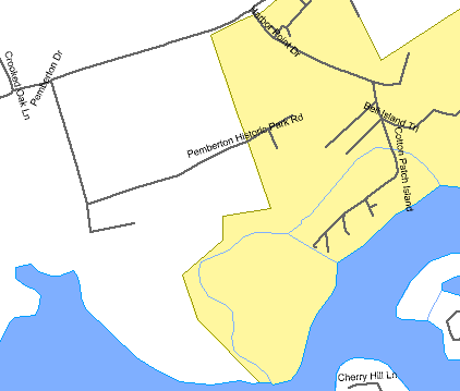
Present day Wicomico County: Pemberton Historical Park (white) is situated directly next to Harbor Pointe Development (yellow).
“When
they were developing Harbor Pointe, you have to say enough is enough and I can’t
do anything about it. And it hurts. For
example, I know where a number of prehistoric Indian sites are.
I can’t do anything about it. That
is also the site of Handy Hall. (Handy Hall was built by George Handy, Isaac’s
son, in 1750). They started
excavating for this house and lo and behold they hit the foundation of Handy
Hall. That is one of the most important structures in the county
and there is nothing you can do about it.”
And
herein lies the juxtaposition of values that characterize Wicomico County.
In Pemberton Historical Park, we see the strong senses of preservation
and history coming to life. But,
surrounding that area, we see the same economically driven ideals that have
been carried over from Isaac Handy’s time.
To me, it didn’t make much sense.
“Why
would there be so much preservation in one area, but right next to it, heavy
development?” I asked.
“We
had to concentrate it. It had to be done and you have to make some hard choices.
You can’t save everything. If
you try to save everything, you get nothing,” Bill explained carefully.
He was obviously speaking from deeply personal experiences.
The
development of Harbor Pointe on the banks of the Wicomico marks a transition
in the value of waterfront property. Rather
than a scenic amenity, waterfront property in the 18th century was
necessary to maintain good business, as rivers acted as the major highways. With industrialization, rivers soon grew to become noisy,
busy, and an overall disagreeable place to live.
This, in addition to the development of roads, the choice property
became that closer to roads. More
wealthy homeowners began to construct homes nearer to roads and further from
waterways, to avoid distractions and enjoy the natural settings around them.
Waterfront property was left to poorer families, who could not afford
to move from the unattractive river. As
business gradually moved from the river and to the highway, suburban sprawl
attracted families to move into suburbs and away from the river.
As less people lived on the river, the property once again became the
choice for the richer people of the county.
Specifically, along the Wicomico, the industrialized portion of the
river is associated with apartment complexes and town homes, whereas the less
developed portion of river is filled with larger homes, mansions, and
exquisite subdivisions, like Harbor Pointe.
When
dissecting the values of the developers and preservationists, we must take the
same mindset as we did with Isaac Handy:
we must regard them as people of their time.
Unfortunately, in 1960’s Salisbury, many people valued land by the
dollar. Shockingly, this fact remains basically unchanged since Isaac’s
time. Along the same lines, the
land that was valued economically changed differently from that which was
valued for restoration and conservation.
Unless land had some historical significance that could be proven by
willing individuals, developers had no problem developing their land. Ironically, in order to preserve Pemberton Historical Park as
a monument to our past, we had to fight against the very same economic values
that Isaac Handy and his peers held 300 years ago. This is not criticism of developers. Developers probably believed that developing the land would
make the county a better and safer place in which to live. However, until the value of land is viewed from a less
economical and more culturally significant standpoint, all land is vulnerable
to development, even that which may contain some of the richest history that
exists in the United States. This
is why the juxtaposition of values remains today.
Just
as Isaac Handy’s economic value of the land enacted changes on that land, so
did the restoration and conservation of Pemberton Manor.
Presently, Pemberton Historical Park is the second largest open park
out of the 64 open parks in Wicomico County.
The land looks much different from the mid 18th century:
there are no bustling industries, no slaves, more forests, no boats
unloading on the wharf, and fewer buildings.
As the development of the land has slowed, the life underneath and
above the surface has begun to return. The
soil is beginning to restore itself with nutrition, as evidenced by the growth
of ruderal species, such as annual weeds, that have replaced the stretches of
sand that once dominated the property. Similarly,
along the banks of the Wicomico and on either side of the open field, tree
species like the White and Red Cedar have returned to form growing forests,
wetlands, and swamps. And perhaps
the most celebrated homecoming is that of the people. There has been a steady increase in the number of visitors to
this land since the restoration of Pemberton Hall and Manor.
There always seem to be a few cars parked in the oyster shell parking
lot and a few trail hikers making their way around paths enjoying the prime
natural setting on the Wicomico River. In
so much as the land continues to be conserved and valued, it will continue to
replenish itself. Noticing these
changes brings up an interesting question:
What would this land have looked like if it were never saved?
Beyond
Pemberton Hall, there are just two other structures on site:
an educational center and an historical museum.
This may strike some as strange. They
see a historical park supposedly preserving 18th century life and
wonder, “Would Isaac Handy have built an educational center on his land?” When we ask this question, we must realize how much has
changed since Isaac’s time. Today,
at Pemberton Historical Park, people believe that the land can be conserved
not only as a record of life, but also as a means for developing environmental
awareness. Pemberton Historical
Park celebrates the value of land, in its historic, cultural, educational, and
natural senses. In doing so, the
park not only commemorates our colonial past, but the present day in which we
live.
The
bottom line is that value differences affect the land.
From the rise of Isaac Handy, to life after Isaac, to the restoration
proclamation, the values that people held onto were reflected in the way the
land was treated. And, consequently, the treatment of the land brought upon new
situations and opportunities for the next generation.
Without Isaac Handy’s development of the land, we would have had no
reason to preserve it. However,
if the land were not properly treated to begin with, Isaac would have had no
reason to develop it. This simple
recognition that the use of the land has changed is also evidence that the
values of the people have changed.
When
we inspect our values and why we believe in them, we must realize what impacts
they may have on the land. We must recognize how we value land. Is it economically valued or culturally valued? Is there a
healthy balance? These are
questions that we must answer for ourselves in order to protect both the land
and the needs and values of our society.
Once we, including both citizens and lawmakers, begin to treat the land
in accordance with balanced values, it cannot be mistreated by harmful
development or negligence.
Bill
Wilson sits across from me, addressing his future relationship with the park:
“As long as I am here, that house will never have barriers in it. I want it to be a living history version.
I want to be able to take school kids in there, and sit them on the
floor, and dress them up and talk to them and pick things up to show them and
talk to them about history and have it come alive for them.
And that is fun. And if it
stops being fun, I guess I won’t be involved.
What else can I answer?”
“I
think that is it. I’ve gotten a
wealth of information,” I say, standing up to shake Bill’s hand.
Bill
walks with me downstairs, out of the education center and to my car, still
chatting about his ideas for new education opportunities at the Park.
I say goodbye, and am on my way down Plantation Lane. As I am making my way around the dogleg near the wharf, a
vision forms in my head. Where
Pemberton Hall was once standing exists a modern looking house with a deck and
a trampoline and a Gazebo by the river. Next
to it, and all around it, are exact replicates.
There are roads, street lamps, and stop signs. It is a pleasant little neighborhood called “Pemberton’s
Good Will.” Suddenly, my mind
flashes back to reality, and I am on the gravel road passing the worm fences
and baby apple trees. A warm
feeling has just blossomed in my spirit, one of thankfulness for the
preservation minded people who had the desire to save and restore this land. I look back to see Pemberton Hall, the open field, the
fences, and the Wicomico River in the distance.
I am happy that within my vision exists not only a monument to the rich
history of the Eastern Shore, but also a true reflection of how we value and
treat land today in Salisbury, Maryland.
[1] Handy, Isaac W, D.D. “Annals and Memorials of the Handys and their Kindred.” William L Clements Library. Ann Arbor, Michigan, 1992 p.17-19.
[2] Handy, Isaac W, D.D. p.17-19
[3] Handy, Isaac W, D.D. p.17-19
[4] Samuel Handy, Sr.’s Will. Prerogative Court of Maryland. Liber: 17 folio 24
[5] Handy, Isaac W, D.D p.2-4
[6] Samuel Handy, Sr.’s Will. Prerogative Court of Maryland. Liber: 17 folio 24
[7] Green Carr, Lois. P.353-354
[8] Samuel Handy, Sr.’s Will. Prerogative Court of Maryland. Liber: 17 folio 24
[9] Samuel Handy, Sr.’s Will. Prerogative Court of Maryland. Liber: 17 folio 24
[10] Green Carr, Lois. P.353-354
[11] Per Bill Wilson
[12] Handy, Isaac W, D.D. p.17-19
[13] Handy, Isaac W, D.D. p.17-19
[14] Truitt, Charles J. p.20
[15] “Staple crops and Urban Development in 18th Century South.” Perspectives in American History, x (1976) 5-78
[16] “Staple crops and Urban Development in 18th Century South.” Perspectives in American History, x (1976) 5-78
[17] Russel R. Menard, “Immigrants and their Increase: the process of population growth in Early Colonial Maryland” in Aubrey C Land, Lois Green Carr, and Edward C Popertive, etc. “Law, Society, and Politics in Early Maryland” (Baltimore, 1977) 98-99
[18] Green Carr, Lois. P.354
[19] Menard, Russel R. p 98-99
[20] Menard, Russel R. p.98-99
[21] Pemberton Historical Park Sign
[22] Per Bill Wilson
[23] Isaac Handy’s Inventory. Inventories of the Prerogative Court. Liber 81 folio 303 and Bill Wilson
[24] Bradley, Sylvia. “Pemberton News” April, 1982. Vol 3. No. 2
[25] Stump, Bruce Neal. “Somerset County, A Pictoral History.” 1985. Donning Co. Publishers, Norfolk. p.20
[26] Truitt, Charles J. p.20
[27] Green Carr, Lois p.378-379
[28] Isaac Handy’s Inventory. Inventories of the Prerogative Court. Liber 81 folio 303
[29] Green Carr, Lois p.378-379
[30] Isaac Handy’s Inventory. Inventories of the Prerogative Court. Liber 81 folio 303
[31] Green Carr, Lois p.381-382
[32] Truitt, Charles J. p.20
[33] Truitt, Charles J. p.20
[34] Handy, Isaac W, D.D. p.17-19
[35] Archives of Maryland, vol xxxvii. Proceediings and Acts of the General Assembly of Maryland. May, 1730 to August, 1732, p.537-540.
[36] Archives of Maryland, vol xxxvii. Proceediings and Acts of the General Assembly of Maryland. May, 1730 to August, 1732, p.537-540.
[37] Bradley, Sylvia and Thompson, G. Ray. “Historic Salisbury: An Exhibit and Catalogue of Documents and Artifacts Tracing the Growth and Evolution of the Town of Salisbury in Maryland. c.1730-1960.” April, 1991. Salisbury State University. P.3
[38] Cooper, Richard. “Salisbury in Times Gone By” p.20
[39] Torrence, Clayton. “Old Somerset on the Eastern Shore.” Whittet and Shepperson. Richmond, Virginia, 1935. P.275-77
[40] Torrence, Clayton. P.275-277
[41] Truitt, Charles J. “Historic Salisbury Updated: 1662-1982” Country Life Press. New York, 1932 p.24
[42] Truitt, Charles J. p.24
[43] Per Bill Wilson
[44] Truitt, Charles J. p.24
[45] Pemberton Hall Foundation publication, 2002.
[46] Per Bill Wiilson
[47] Bradley, Sylvia. “Pemberton News” Jan, 1982. vol 3, no.1
[48] Per Bill Wilson
[49] Handy, Isaac W, D.D. p.17-19
[50] Handy, Isaac W, D.D. p.17-19
[51] Handy, Isaac W, D.D. p.17-19
[52] Handy, Isaac W, D.D. p.17-19
[53] Torrence, Clayton. P.275-277
[54] Schaun, George and Virginia. “Everyday Life in Colonial Maryland” Greenberry Publications. Annapolis, Maryland, 1959. p.4
[55] Per Bill Wilson
[56] Per Bill Wilson
[57] Green Carr, Lois p.344-345
[58] Green Carr, Lois p.344-345
[59] Green Carr, Lois p.344-345
[60] Stribling, J.M, Barse, A.M., Grecay, P.A., Hunter, R.B., Maloof, J.E., H.E. Womack. “Ecology 225 Lab Manual, Spring 2002” p.36
[61] Per Bill Wilson
[62] Per Bill Wilson
[63] Per Bill Wilson
[64] Per Bill Wilson
[65] Per Bill Wilson
[66] Per Bill Wilson
[67] Rountree, Helen, Davidson, Thomas. “Eastern Shore Indians of Virginia and Maryland.” University Press of Virginia. Charlottesville, Virginia. 1997. p108-110.
[68] Rountree, Helen, Davidson, Thomas. p.113
[69] Rountree, Helen, Davidson, Thomas. p.33-34
[70] Rountree, Helen, Davidson, Thomas. p.34-35
[71] The comparison of English Colonist and Indian effects on the land is similar to that described by William Cronon in his book, “Changes in the Land: Indians, Colonists, and the Ecology of New England.” Hill and Wang. New York, 1983.
[72] Schaun, George and Virginia p.4
[73] Handy, Isaac W, D.D. p.17-19
[74] Per Bill Wilson
[75] Per Bill Wilson
[76] Per Bill Wilson
[77] The Daily Times, Jan. 23, 1972
[78] The Daily Times, Jan. 25, 1972