Chapter Thirteen
Conservation: An Idea Is Born
Jennifer
Banham
What
are the natural features which make a township handsome-and worth going far to
dwell in? A river with its
water-falls---meadows, lakes---hills, cliffs or individual rocks, a forest and
single ancient trees---such things are beautiful. They have a high use which dollars and cents never represent.
If the inhabitants of a town were wise they would seek to preserve
these things though at a considerable expense.
[1]
This is how Henry David Thoreau thought of the river in his town of Concord, Massachusetts in 1861. It reminds me of the Wicomico River, here in Salisbury. Thoreau knew rivers can offer a lot to the people of a town. It was essential to him that a community has public lands, and he wanted those lands to be wild. Keeping civilization with wild areas nearby was a belief Thoreau held strongly. [2] Rivers do not need only to be used to better our economy, but also for the recreation of our families. At the same time that the Wicomico River is being used for oil transportation, it can be used for an afternoon out fishing, or canoeing. The Wicomico River has the potential to be a Thoreauvian river; it can be a river that allows our community to reap the benefits of its wildness.
Today, as you paddle south down the Wicomico River, you notice the change of landscape along the river as you leave Salisbury. The wildness of the river begins to jump out at you as you near Pemberton Park. Many industrial uses of the river can be seen inside city limits. Much of the land surrounding the river outside of city limits is agricultural and suburban. These forms of development take a toll on the quality of water in the Wicomico. The river has been turned into an industrial machine over the years. Humans have diverted the river’s natural energy to benefit themselves; the river’s energy can be used to reduce the need for human energy. The city of Salisbury depends on the power and energy of the Wicomico to transport goods at a low cost. Even on a Saturday morning in April, I see a barge carrying fuel to Delmarva Oil as I paddle my canoe along. Effects of using the river as an industrial tool are noticeable. The river is not as clean as it once was, nor does it boast the fish populations that it once did. But the condition of the Wicomico is improving. Citizens of Wicomico County do not recognize the Wicomico River to be as pristine as its sister rivers, the Nanticoke and the Pocomoke. But that is changing. Awareness is growing. The community is realizing that the Wicomico River can be a Thoreauvian river.
Nature and forests were considered infinite resources by most Americans, until the end of the Nineteenth Century. Then more Americans started to recognize the nation’s carelessness toward our natural resources; they began to believe these resources were not infinite, and needed to be managed for the prosperity of the future. The first National Park was dedicated during this time, in 1872. Ideas for protecting our nation’s wild lands were reaching an all time high by the turn of the Twentieth Century. [3] On December 3, 1907, President Theodore Roosevelt addressed this issue during his Seventh Annual Message to Congress. He stated, “The Conservation of our natural resources and their proper use constitute the fundamental problem which underlies almost every other problem of our National life. We must maintain for our civilization the adequate material basis without which that civilization cannot exist.” [4] The reasonable use of the Earth’s natural resources is the focus of conservation. Conservation consists of managing the land and water to maintain the greatest benefits for the greatest number of beings, including both humans and wildlife. Conservation seeks to prevent the waste of natural resources, control pollution, and maintain a quality environment for future generations. [5] If we do not conserve some of the wild lands we use today for public use tomorrow, our children and grandchildren will not benefit from them in the same way that we have. Consider your favorite park or forest; it is most likely managed for the benefit of your enjoyment and the sustained needs of the community.
Conservation was nationally accepted well before it appeared on the Eastern Shore of Maryland. As a value and belief system conservation has been weak along the Wicomico River, and in the Chesapeake Bay Watershed as a whole. Although the need for conservation was recognized much earlier on the Chesapeake Bay, it took Maryland citizens quite some time to realize that the tributaries, such as the Wicomico River, affect the Bay enormously. Conservation was almost non-existent in the United States until the Twentieth Century, and on the Eastern Shore of Maryland until the 1960’s. Even now, conservation ideas on the Eastern Shore are present, but only as minority positions. Wicomico County’s awareness about recent threats to our wild lands, such as sprawl and development, is growing. Along the Wicomico River, most of the land has been heavily developed, but there remain select areas, such as the northern watershed of Johnson Pond, Ellis Bay Wildlife Management Area, and Pemberton Park, which are managed to conserve wildlife and the natural heritage of the area.
The Conservation Idea Evolves
People started thinking about the land in new ways during the Nineteenth Century. Writers like Henry Thoreau were calling for the protection of wildlands by the 1850’s. Thoreau was one of the first Americans to believe that it was important to protect certain areas of wilderness solely for their intrinsic value. [6] This is a belief commonly held by preservationists. Many people easily confuse preservation with conservation, but the two are actually very different. Preservation is the protection of land based on its inherent value and beauty as Nature untouched by humans; conservation consists of using the land in multiple ways to the benefit of humans while still keeping the land as close to its natural state as possible. Lands held for preservation are allowed to grow freely and naturally, while conservation lands are managed for the most use. [7] Although some people were already thinking about preservation and conservation, many did not give the two ideas much thought until they realized the eastern part of the country had been completely altered for the human community, and also that the western frontier had officially closed in 1890.
By the end of the Nineteenth Century, much of the eastern forests had been destroyed through careless burning for farmlands and logging for construction or fuel. [8] Our nation’s environment seemed to be in trouble. Then in 1901, Theodore Roosevelt became the nation’s twenty-sixth president. After finishing McKinley’s term, Roosevelt was re-elected for a second term and served as President until 1909. [9] He was considered a rugged man with a passion for the outdoors. Many believe, “some of Roosevelt’s most effective achievements were in conservation.” [10] Although more and more Americans were becoming aware of the destruction of their nation’s forests and resources, this new President served as the catalyst to action. With Roosevelt’s assumption of the presidency, the conservation movement had officially come to power. Other Presidents had made contributions but Roosevelt was the first to bring the new idea to the mainstream public. [11] Many of the conservation ideas we practice today were brought to light by President Roosevelt and his chief of forestry, Gifford Pinchot. President Roosevelt and his forestry expert Gifford Pinchot were good friends. [12] “If any man was more closely identified with the great conservation movement of the early 1900’s than Theodore Roosevelt, it was Gifford Pinchot, chief of the Bureau of Forestry (later the Forest Service) and the President’s principal advisor on conservation.” [13] Pinchot was the first American to train deliberately for a career in forestry management. He attended college in Europe for an adequate education in the field, where he invented the idea of sustainable-yield in forestry. [14] Pinchot and Roosevelt believed in wise-use of the Earth’s resources, so that following generations could survive the way they had. Gifford Pinchot greatly influenced President Roosevelt’s policies.
Many of the public land use policies we use today, even in Wicomico County, began in the Roosevelt-Pinchot era. In those days, most Federal lands resided in what was called the Public Domain, lands eventually to be sold for revenue to run the government. [15] But Roosevelt, Pinchot, and others felt if all the valuable forested lands fell into private hands, those hands would belong primarily to ‘lumber barons.’ They were worried by the predictions of the time estimating that at the current rate of logging sweeping across the United States, we would deplete the nation’s timber supply in sixty years. [16] “So, Roosevelt, with the help of Pinchot and his forestry bureau, quickly began setting aside millions of acres as Forest Reserves.” [17] By the end of Roosevelt’s presidency, nearly 234 million acres had been set aside as Forest Reserves, now known as National Forests. [18]
This attempt to keep forests in public control, for sustainable use, was seen on the Eastern Shore as recently as 1999. With help from the Conservation Fund and the Mellon Foundation, the state of Maryland was able to purchase 58,000 acres of privately owned forests from the Chesapeake Forest Products Company, in the Autumn of 1999. This was the biggest land acquisition for conservation in Maryland’s history. The goal for the Chesapeake Forests is to manage them for conservation purposes including sustainable-yield forestry, wildlife habitat, and public recreation. The Chesapeake Forests are not managed nationally, as the National Forests are, but they are a huge step in conservation for the Eastern Shore and the State of Maryland. It proves the state is thinking about the health of its land. Natural habitat, including forest buffers, has profound effects on the health of a river. Thousands of acres of the Chesapeake Forests can be found as forest buffers along the Wicomico River. The acquisition of this land is helping the local rivers such as the Wicomico to become Thoreauvian rivers by protecting their wild surroundings. Many of these newly acquired acres are found at the south end of the river, near Ellis Bay Wildlife Management Area.
National
Wildlife Refuges & Wildlife Management Areas
The Forest Reserves were not the only conservation areas set up by the Roosevelt administration; National Wildlife Refuges also sprung out of Roosevelt’s presidency. [19] Since the beginning of the conservation movement focused on protecting forests, and wildlife, the National Wildlife Refuges were set aside to protect different species of animals and birds, and their habitats. The first National Wildlife Refuge was established in Florida, in 1903. Pelican Island was dedicated by President Roosevelt to protect nesting birds. [20]
Today, there are more than 475 National Wildlife Refuges (NWRs) protected, with at least one in every state. These areas cover 91 million acres and protect almost every kind of wild animal native to this continent. There are more than 220 species of mammals, 600 species of birds, 250 types of reptiles and amphibians, and over 200 species of fish protected in these areas. [21] Most refuges are open to the public for wildlife-oriented activities, the most common being nature observation, photography, and hunting. [22] Although no NWRs are located along the Wicomico River, there are four established on the Eastern Shore: Blackwater National Wildlife Refuge in Cambridge, Bombay Hook NWR and Prime Hook NWR, in Delaware, and Chincoteague NWR located on Assateague Island.
Blackwater National Wildlife Refuge was established in 1933, for the protection of migratory waterfowl. It is composed of 17,121 acres of rich, tidal marsh, plus freshwater ponds, mixed woodlands, and a small amount of cropland. [23] “Although originally established for ducks, Blackwater has become one of the chief wintering areas for Canada geese using the Atlantic Flyway.” [24] Blackwater is also the home of three of our nation’s endangered species, the bald eagle, the Delmarva fox-squirrel, and the Peregine falcon. [25] It is evident that this area is critical to the existence of these endangered species, and should be conserved to maintain not only their current populations, but also the natural beauty of the land for human recreation as well.
Another refuge located on the Eastern Shore is Chincoteague National Wildlife Refuge on the south end of Assateague Island. Like all National Wildlife Refuges, Chincoteague is maintained by the U.S. Park and Wildlife Service. [26] Chincoteague was also established to protect migrating birds, but this area was not dedicated until 1943, ten years after Blackwater National Wildlife Refuge. Over one hundred species of migrating birds can be seen there on any given day. Some of the species include swans, ducks, herons, egrets, snow geese, and gulls. Chincoteague is also famous for its wild ponies and other resident mammals. [27] The mission of the refuge is stated as, “[t]he primary function of the refuge is to protect native and migratory species of wildlife and their habitat. The refuge is open to recreational uses centered around wildlife and wild land activities that are in harmony with this primary objective.” [28]
National Wildlife Refuges are dedicated and managed on a national level, but states also protect lands they feel are sensitive for wildlife habitat. Wildlife Management Areas (WMAs) are managed by states, because they are not considered important enough to be picked up by the National Fish and Wildlife Service. In Maryland, the Department of Natural Resources maintains the WMAs, such as Ellis Bay located at the mouth of the Wicomico River. [29] Maryland’s WMAs “are as diverse as Maryland itself, ranging from stands of mountain timber best measured in square miles to expansive Eastern Shore marsh. Across the state, 37 WMAs total more than 91,000 acres of land devoted to wildlife conservation.” [30]
Ellis Bay Wildlife Management Area
The Maryland DNR purchased Ellis Bay Wildlife Management Area in parcels, beginning in 1957. [31] The first parcel located at the mouth of the Wicomico River, on the North side, was 1,304 acres. The most recent purchase was in 1991, and totaled 780 acres. Ellis Bay Wildlife Management Area was still undeveloped and available for the state to purchase as late as the 1950’s, because the area is not suited for farmland or houses. The land at Ellis Bay has little economic value; the state purchased the land because no one else had developed it.
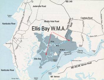
Figure 1: Courtesy of Maryland Department of Natural Resources
Mostly marsh and forested wetland, Ellis Bay is now a 2,873.9 acre tidal salt marshland. Most of the WMA is best seen by boat, due to the fact that there are few access roads and little parking. Hunting and fishing are among the favorite activities of visitors to Ellis Bay. [32] This Wildlife Management Area is a Pittman Robertson Fund Project. The Pittman-Robertson Wildlife Restoration Act, formally known as Federal Aid in Wildlife Restoration Act, was first passed in 1937. [33] The Pittman-Robertson Act “provides federal aid to the states for the management and restoration of wildlife. This aid, funded through an excise tax on sporting arms and ammunition, may be used to support a variety of wildlife projects, including acquisition and improvement of wildlife habitat.” [34] The state was aided by the federal government in finances to purchase all of this area, except the last purchase in 1991, which was bought through Program Open Space funds. [35]
Timber harvests are allowed at WMAs, but none are planned for Ellis Bay at the moment. The management area is open to the public twenty-four hours a day, and no permits are needed for recreational activities, including hunting. Permits are required for trapping though. [36] The management objectives of Ellis Bay divide the area in two compartments. The first compartment is the open marshland, and is managed for ducks. The second compartment is the woodland, dominated by loblolly pine, which is managed for deer, with squirrels and songbirds in mind. [37] The goal of management at Ellis Bay is to preserve the natural habitat, meaning little alterations are done to the landscape. Since most of the area is wetlands, under current environmental laws little alterations are allowed to take place. Because the landscape has changed so little, the population of resident wildlife species has also changed very little. Wildlife species found at Ellis Bay include deer, quail, ducks, geese, swans, migratory birds, rabbits, woodcocks, muskrats, raccoons, otters, minks, opossum, bald eagles, foxes, songbirds, reptiles and amphibians, and non-game mammals. [38]
Ellis Bay Wildlife Management Area is not the best attempt at conservation on the Wicomico River, but it is a good one. The land at Ellis Bay is not extremely productive, restraining the conservation efforts there. None the less, Ellis Bay WMA is good for the Wicomico River, because it supplies natural buffers along the river. Ellis Bay contributes to the Thoreauvian aspect of the Wicomico River, because it provides a natural, wild place for the nearby citizens to enjoy the nature of the Eastern Shore.
Pemberton Historical Park
While National Wildlife Refuges and Wildlife Management Areas are run by the nation and the state respectively, many parks are managed on the local county level. Wicomico County manages the best conserved area on the river, because it encompasses all of the goals of conservation. Pemberton Park not only preserves the natural landscape of the Eastern Shore, and the heritage of Wicomico County, it also provides many different activities for the nearby community. Pemberton Park boasts 207 acres that allow, “the opportunity to hike 4.5 miles of natural trails, appreciate the beauty of nature and participate in environmental education, historical interpretation or special event activities.” [39]
Pemberton Park is owned and operated by the Wicomico County Department of Recreation, Parks and Tourism. In 1970, the county purchased 64 acres surrounding Pemberton Hall with funds from Maryland’s Program Open Space, and in 1980 Pemberton Historical Park was officially created. Located within Pemberton Park is the Wicomico County Heritage Center, which is owned and operated by the Wicomico Historical Society. Exhibits there are rotated on an annual basis and feature historic displays of items indigenous to Wicomico County and the Eastern Shore of Maryland. [40]
Since the formation of Pemberton Park there has always been a conflict of interests between the people who oversee it. Lands that are conserved almost always produce conflicts between the people who manage the land. At Pemberton, there are three groups with conflicting interests for the park. The Pemberton Hall Foundation wants the area to be fully reconstructed as the 18th Century plantation it once was. This would mean no dogs will be allowed in the park due to the presence of plantation animals like sheep and hens, and environmental education programs will take the back seat to historical research. The Wicomico County Department of Recreation, Parks and Tourism’s interests lie in providing a natural area for the public’s recreation, including frisbee, hiking, and dog-walking. Then there are park naturalists, among others who would like to see the land at the park conserved more, with smaller hiking trails. [41] Certainly the different elements of conservation come into conflict at Pemberton Park, as they do with many parks across the nation. The public wants to be able to walk their dogs there, and wishes for the continuation of environmental education program, while the Pemberton Hall Foundation wants to use Pemberton Park to preserve the natural heritage of Wicomico County.
The Wicomico County Heritage Center, also located in Pemberton Park, is owned and operated by the Wicomico Historical Society. Exhibits there are rotated on an annual basis and feature historic displays of items indigenous to Wicomico County and the Eastern Shore of Maryland. [42] The Wicomico County Heritage Center is also involved in the environmental education programs at Pemberton.
Along the trails at Pemberton Park there are two observation docks that are located on the Wicomico River. These docks are perfect places to catch the sunset over the river. If you are lucky you may catch sight of an osprey, or blue heron. Bald Eagles are also known to take refuge in the park. Personally, I agree with the public and believe that Pemberton Park would be best conserved as a natural area for the nearby citizens. This would allow the public access to the natural landscape of the river, including the observation docks. If Pemberton Park were conserved in this way, it would surely be a Thoreauvian river.
The National Wildlife Refuges and Wildlife Management Areas that are seen here on Maryland’s Eastern Shore represent the goals of the early conservation movement. These goals were to protect and manage wildlife and natural lands for future use. The conservation movement was the pre-curser to the broader, more modern, more powerful environmental movement. [43] By the mid-twentieth century the environmental movement grew into concern for issues such as pollution, air quality, water quality, and population growth. The concern about how these issues impacted human health also became prevalent. The conventional conservation organizations such as the Sierra Club, Izaak Walton League, Wilderness Society, and Audubon Society, which were established during the early conservation movement, experienced an enormous boost in membership during the 1960’s. [44] Environmentalism became a mass movement.
The 1960’s:
Environmental Masses
The early conservation movement was constrained to a minimum of people who were either hunters who wanted to preserve game populations, or wealthy, older people who had time to spend advocating for land protection. Kirkpatrick Sale examines this very issue in his book, The Green Revolution. He describes how the 1960’s changed the conservation movement and broadened it into the environmental movement we know today. Sale explained the heightened interest in the movement when he said, “[b]ut now for the first time the impact was felt throughout society, and now environmentalism moved from being the concern of the affluent and elderly of the boardroom on the one hand or the backwoods hunters and fishers on the other, to being the stuff of everyday life-and politics-for millions.” [45] Many people were now concerned with society’s effects on the land, and the cycle that manifested. Now, not only did people affect the land, but it was apparent that the land affected the health of society. This pollution cycle brought new issues to the environmental front. [46] Society became concerned with the quality of the Earth’s air and water, and how humans were perpetuating the pollution of both. This was crucial for the Chesapeake Bay and the Wicomico River; the health of both water bodies was deteriorating quickly.
Today, human’s effects on the Wicomico River are obvious. There is no swimming allowed in the river, or any of its ponds. Many industrial businesses are located directly on the banks of the river. The city of Salisbury runs on an antiquated wastewater treatment plant, sometimes allowing thousands of gallons of untreated wastewater to run directly into the Wicomico River. These are the issues that have concerned citizens since the transformation of the environmental movement in the 1960’s. Just as the traditional conservation movement was slow to hit the Eastern Shore, so is the concern about pollution. Citizens are just now beginning to worry about contamination and pollution of the land and water. As the traditional conservation idea grew into the larger, broader based, pollution-oriented environmental movement that had gotten so many new citizens involved, the awareness about pollution in Wicomico County may also create a broader environmental movement here. Enough people in Salisbury are beginning to worry about the health of the Wicomico River that environmental groups are forming, just as they previously have for the nearby Nanticoke River.
There were many environmental regulation breakthroughs during the 1960’s. The Clean Water Act was passed during the beginning of the decade, in 1960. Additions to this law were the Water Quality Act and the Water Quality Control Act, passed in 1965 and 1970. [47] These regulations were and still are very effective for the Wicomico River, and the Chesapeake Bay. The primary objective of the Clean Water Act is to restore and maintain the integrity of the nation’s waters. This objective translates into two national goals:
1. Eliminate the discharge of pollutants into the nation’s waters, and
2. Achieve water quality levels that are fishable and swimmable. [48]
The Chesapeake Bay was listed as an ‘impaired waterbody’ under the Clean Water Act due to excess nutrients and sediments. [49] The nation’s waterways, including the Chesapeake Bay have improved since the emergence of the Clean Water Act. In 1972, only 1/3 of the nation’s waters were safe for fishing and swimming. Wetlands losses were estimated at about 460,000 acres annually. Today, we see improvements…2/3 of the nation’s waters are safe for fishing and swimming, and the rate of annual wetlands loss is estimated at about 70,000-90,000 acres. [50] Although the Clean Water Act was successful in cleaning up many of the nation’s waterways, the Wicomico River still remains unsafe to fish and swim in. The Bay and our nation’s waters have suffered greatly at our hands, but they have been improving in the last thirty years. Hopefully one day we will once again be able to swim in the waters of the Eastern Shore.
One major conservation organization founded to help the Chesapeake Bay established itself during the 1960’s, as the rest of the nation was beginning to worry about our nation’s waters. The Chesapeake Bay Foundation was launched in 1966; it is the largest conservation organization solely dedicated to saving the Chesapeake Bay. [51] It boasts 100,000 active members. The Chesapeake Bay Foundation works through implementing environmental education programs, environmental protection, and restoration projects. The foundation is largely recognized by its simple and direct mission statement, “Save The Bay.” [52] Through educating the public about the conditions of the Bay and providing a safe recreational area for the citizens to engage in its wildness, the Chesapeake Bay Foundation is working to make the bay and its tributaries Thoreauvian areas.
The environmental movement and the formation of such organizations as the Chesapeake Bay Foundation represent a bottom-up form of action. Bottom-up action refers to a movement based on the citizen’s actions to protect something. This method is very helpful in getting the masses aware and involved. Although getting the public involved is very effective, sometimes the government is needed to step in and enforce regulations with new laws. When the government enforces new regulations it is considered a top-down method, because the people in high positions step in and try to get something done through new legislation. To reach long-lasting environmental change there must be a combination of the two methods to action. True environmental change consists of the public organizing themselves and the government using its law-making power to regulate activities.
Recent Environmental Laws
Many state and local regulations poured out of legislation, after the realization that the Bay was in danger. Citizens began to recognize the importance of maintaining the quality of the Bay’s tributaries for the overall health of the Chesapeake Bay. The health of the Bay’s tidal wetlands, such as the Wicomico River, were now considered very significant to conserving fish and wildlife populations. Two major environmental laws were established to protect these vital wetlands; they were the Tidal Wetlands Act of 1970, and the Chesapeake Bay Critical Area Law of 1984.
Marylanders quickly stepped to action and established some of the first laws to protect the Bay and its tributaries. “In 1970, the Maryland General Assembly recognized that many wetlands had been lost or despoiled throughout the State by unregulated activities such as dredging, dumping, and filling, and that remaining wetlands were in jeopardy.” [53] The result of this realization was the Tidal Wetlands Act of 1970. This law was established to restrict and regulate development activities in wetland areas in order to conserve them. [54] Wetlands are extremely important to Salisbury and the Eastern Shore’s economy through the plants and wildlife that reside there. The enactment of the Tidal Wetlands Act is very influential on the Wicomico River, because it is tidal, and must follow these regulations. Many of the activities listed above as being regulated under this act have taken place on the river for quite some time. Dredging is important in keeping the Port of Salisbury open for the transportation of fuels and such into the city. The citizens of Wicomico County began “improving” the Wicomico River, by dredging it, in 1872. It sadly took citizens one-hundred years to realize the environmental impacts of dredging. The Tidal Wetlands Act will help maintain the Wicomico River as a Thoreauvian river by regulating activities and protecting its natural landscape.
Marylanders have made other attempts at maintaining the Eastern Shore’s wild landscape. In 1984, the Maryland General Assembly once again set out to protect the Bay and its tributaries. [55] The very complicated Chesapeake Bay Critical Area Law was established in 1984, and the criteria completed by 1986. This law was created to establish a 1,000 feet buffer zone from the mean high tide or the edge of tidal wetlands. [56] The state established the Chesapeake Bay Critical Area Commission to formulate the criteria for the law, and evaluate local programs. The new law gave local jurisdictions until June 1988 to meet state standards and implement their Critical Area Plan. [57] Compliance of the Critical Area Law is also the responsibility of local jurisdictions. “The purpose of the law is to regulate activities within 1,000 feet of tidal waters of the Chesapeake Bay with the intent of improving the water quality and habitat in the Bay.” [58] We know the banks of a river effect the river’s water quality, and this law was established to protect those river banks.
Maryland was also a pioneer in a new law attempting to regulate development. “Smart Growth is a concept that provides open spaces from over development. The idea behind this is to build around existing sewer and water systems, roads, schools, and other public services. This philosophy concentrates development in towns and cities rather than encouraging sprawling suburban and ex-urban development that destroys ecologically fragile areas.” [59] Maryland’s Smart Growth idea has become an example for other states development plans. Smart Growth does not seem to have worked in Wicomico County; the county is daunted by sprawl development. The state and the county are still attempting to contain growth to the metro core where city utilities are currently located, but continue to find themselves fighting the loss of agricultural land to sub-developments.
The Wicomico River Greenway is the area along the banks of the river dedicated by the county as conservation area. [60] Even though the Wicomico River Greenway is mostly tidal wetlands protected by the Tidal Wetland Act and the Chesapeake Critical Area Law, much of it from Whitehaven to Salisbury has been developed in recent years. [61] This has been allowed to occur either because the development occurred prior to the introduction of these laws, or because the land was already lotted for development, and was grandfathered in the laws.
Canoeing down the Wicomico in April of 2002, one can still witness development of homes directly on the river’s banks. Once out of the city the river has forest buffers along the North side, but many homes on the South side. Wicomico County is thinking about the ways it is affecting the river, and trying to lessen those effects. Their plans are good-hearted. The Comprehensive Plan for Wicomico County proves the county wishes to keep the Wicomico River Greenway as conservation land. [62] They are attempting to conserve the areas around the river, while focusing intensive development outside of the river’s watershed. As you canoe the Wicomico River, the only major attempts at conservation that can be seen are located at Pemberton Park and Ellis Bay Wildlife Management Area. The Wicomico River will never be a wilderness area, but it is wild and can be used for the benefits of wild areas. There is an abundance of waterfowl, and wildlife in the river. I personally saw a pair of foot-long snapping turtles during my canoe trip. As environmental awareness and conservation ideas grow, there is hope for the Bay, and even our river.
2002 is the year of awareness for the Wicomico River. County residents are organizing to fight for the health of their river. Groups such as SOS (Stop Overflowing Our Sewers) are forming. These groups are educating themselves on environmental issues, such as combined sewer overflows, and pollutant contamination. The recent appearance of environmental groups along the Wicomico River proves the residents of Wicomico County are beginning to view the river as a Thoreauvian river; as a river that can be used for recreation as well as industry. The people are beginning to see the benefit of using the river to explore and see wildlife. The Wicomico River is our attempt to help the environment right in our backyards. Many people are concerned with bigger environmental issues such as global warming, air pollution, and water pollution. It is always easier to think of these bigger issues facing the nation, and even the world, but local involvement in Wicomico County is necessary for the bigger picture. If you are worried about the Chesapeake Bay, you must worry about the health of the Wicomico River. It is a much easier task to clean up our little river, than the whole Chesapeake Bay and our community will experience the benefits for a long time.
Think
Globally, Act Locally ~unknown
Conservation keeps both economy and environment in mind! ~unknown